

Access to updated and reliable information is crucial to a more efficient and resilient agricultural production in response to the escalating challenges of food security for the growing population and the impacts caused by extreme weather events. Information derived from remote sensing helps governments and agricultural intermediaries to better manage domestic rice production and distribution, both during normal growing conditions and after natural events. For insurers, such information is essential to reduce the risk and to introduce new insurance schemes affordable for low-income smallholder farmers.
RIICE is a Swiss Development Cooperation (SDC) co-financed program started in 2011 implemented through a public-private-partnership between sarmap, the International Rice Research Institute (IRRI), SwissRe and SDC.
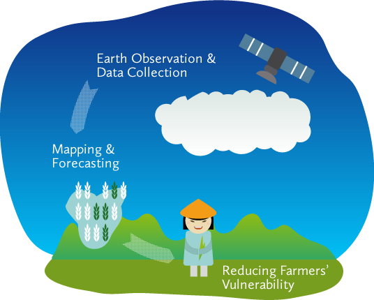
RIICE – When, Where, How much
Seasonal rice cultivated area and phenology are monitored along the entire season using data systematically acquired by satellite Synthetic Aperture Radar (SAR) systems. Coupled with a rice growth model, such remotely sensed data predicts rice yield starting from mid of season, estimate yield at actual harvest time and regularly deliver updated information on the rice production situation. The service – operated by national partners after a know-how transfer phase – has been widely validated in the most diverse rice ecosystems with accuracy rates of around 90%.
Where RIICE is used?
Collectively, RIICE monitored around 12 million hectares of rice cultivated land in Philippines, Vietnam, Cambodia, India, and Thailand. From the technological proof of concept stage, RIICE has been progressing to the implementation and upscaling phase by institutionalizing its technology solution with ministries and, in some countries, with insurance actors. The Philippines government for example has made substantial investment to move to a national-scale monitoring system – PRiSM – which is based on RIICE technology, while insurers in the state of Tamil Nadu use RIICE technology for loss assessments after natural disasters within the governmental crop insurance scheme. With agreements with national ministries in place, the RIICE technology contributes to new rice insurance schemes, such as for example in Vietnam and Cambodia. In Vietnam, RIICE is being considered to be an instrumental data source for the national agricultural insurance scheme.
RIICE technology is continuously evolving by integrating data acquired from new satellite systems, drone data, and by adapting and customizing the service according to countries’ and insurers’ specific needs. The standard product suite consists of:
-
- Baseline maps, i.e. Agricultural and rice area and rice ecosystem zoning;
- Seasonal area, seasonal phenology and bio-physical parameters;
- Seasonal yield forecast and yield estimation at harvest time;
- Flood and drought related rice damage maps.
Latest News
Long-term commitment leads to innovation in national insurance scheme
Swiss funded satellite technology generates big impact in rice monitoring
Vietnam uses remote sensing to monitor rice production
Satellite technology protects smallholder farmers against crop losses
Sentinel-1 speeds up crop insurance payouts
ASEAN-SAS – Satellite technology expedites insurance payouts in India
RIICE flood assessment helps government of Tamil Nadu
Using digital systems to improve food security
Publications
S.P. Kam, F. Holecz, E. van Valkengoed, M. Barbieri, C.B. Casiwan, S.L. Asilo, L. A. Santos, R.G. Manalili, W.B. Collado, S.A. Adriano, and A. Maunahan, The makings of an internet-based rice information system: Piloting in the Philippines, First Symposium on Geoinformatics, Philippines, 2004.
F. Holecz, M. Barbieri, F. Collivignarelli, L. Gatti, A. Nelson, T.D. Setiyono, M. Boschetti, G. Manfron, P. Brivio, E. Quilang, M. Obico, V.Q. Minh, D. P. Kieu, Q. N. Huu, T. Veasna, A. Intrman, P. Wahyunto, and S. Pazhanivelan, An operational remote sensing based service for rice production estimation at national scale, ESA Living Planet Symposium, Edinburgh, 2013.
T.D. Setiyono, A. Nelson, and F. Holecz, Satellite based crop yield monitoring and forecasting, FAO/ADB Crop Monitoring for Improved Foods Security, Proceedings of the Expert Meeting, Vientiane, 2014.
M.R. Mabalay, A. Nelson, T. Setiyono, E.J. Quilang, A. Maunahan, P. Abonete, A. Rala, J. Raviz, R. Skorzus, J. Loro, F. Holecz, M. Barbieri, F. Collivignarelli, and S. Monaco, Rice area mapping and yield estimation for crop insurance in Leyte Province, Crop Science Society of The Philippines, 2014.
A. Nelson and 43 others, Towards an operational SAR-based rice monitoring system in Asia: examples from 13 demonstration sites across Asia in the RIICE project, Special Issue of Remote Sensing in Food Production and Food Security, Remote Sensing 6(11), 2014.
S. Asilo, K. de Bie, A. Skidmore, A. Nelson, M. Barbieri, and A. Maunahan, Complementarity of two rice mapping approaches: characterizing strata mapped by hyper-temporal MODIS and rice paddy identification using multi-temporal SAR, Remote Sensing 6(12), 2014.
A. Nelson, M. Boschetti, G. Manfron, F, Holecz, F. Collivignarelli, L. Gatti, M. Barbieri, L. Villano, P. Chandna, and T. Setiyono, Combining moderate resolution time series RS data from SAR and optical sources for rice crop characterisation: Examples from Bangladesh, Land applications of radar remote sensing, INTECH, 2014.
A. Laborte, A. Nelson, T. Setiyono, J. Raviz, E. Quilang, J. de Dios, M.R. Mabalay, P. Mabalot, F. Holecz, M. Barbieri, A. Rala, F. Collivignarelli, L. Gatti, M. Barroga, E. Quicho, J. Maloom, A. Maunahan, P. Abonete, J.R. Mirandilla, C. Garcia, H. Gonzaga, L. Villano, A. Arocena, H.Z. Bhatti, Mapping and monitoring rice area in the Philippines: the PRISM project experience, Proceedings of The International Remote Sensing Symposium, Taiwan, 2015.
F. Holecz, L. Gatti, F. Collivignarelli, and M. Barbieri, On the use of temporal-spectral descriptors for crop mapping, monitoring and crop practices characterization, IGARSS Symposium, Milan, 2015.
M. Boschetti, A. Nelson, F. Nutini, G. Manfron, L. Busetto, M. Barbieri, A. Laborte, J. Raviz, F. Holecz, M.R.O. Mabalay, A.P. Bacong, and E.J.P. Quilang, Rapid assessment of crop status: An application of MODIS and SAR data to rice areas in Leyte, Philippines affected Typhoon Haiyan, Remote Sensing 7, 2015.
S. Pazhanivelan, P. Kannan, P. Christy Nirmala Mary, E. Subramanian, S. Jeyaraman, A. Nelson, T. Setiyono, F. Holecz, M. Barbieri, and M. Yadav, Rice crop monitoring and yield estimation through Cosmo-Skymed and TerraSAR-X: A SAR-based experience in India, Int. Arch. Photogramm. Remote Sens. Spatial Inf. Sci., XL-7/W3, 85-92, doi:10.5194/isprsarchives-XL-7-W3-85-2015, 2015.
J. Raviz, M.R. Mabalay, A. Laborte, A. Nelson, F. Holecz, E. Quilang, M. Barbieri, J. de Dios, F. Collivignarelli, L. Gatti, A. Rala, C. Garcia, P. Mabalot, J.R. Mirandilla, M. Doverte, Mapping rice area in Mindanao using the first images of Sentinel-1A: The PRISM project experience, Proceedings of The 36th Asian Conference on Remote Sensing, Philippines, 2015.
F. Holecz, L. Gatti, F. Collivignarelli, and M. Barbieri, On the use of temporal-spectral descriptors for crop mapping, monitoring and crop practices characterization, IGARSS Symposium, Milan, 2015.
G. Fontanelli, D. Stroppiana, L. Busetto, M. Boschetti, F. Holecz, L. Gatti, F. Collivignarelli, and M. Barbieri, Rice monitoring using SAR and optical data in Northern Italy, IGARSS Symposium, Milan, 2015.
L. Busetto, S. Casteleyin, C. Granell, M. Pepe, M. Barbieri, M. Campos-Taberner, R. Casa, T. Guarneri, I. Miralles, E. Movedi, V. Pagani, S. Pascucci, L. Ranghetti, E. Ricciardelli, D. Stavrakoudis, D. Katsantonis, F.J. Garcia-Haro, F. Holecz, I. Gitas, M. Boschetti, Downstream services for rice crop monitoring in Europe: from regional to local scale, Journal of Selected Topics in Applied Earth Observation and Remote Sensing, 2017.
M. Campos-Tabernber, F.J. Garcia-Haro, G. Camps-Valls, G. Grau-Muedra, F. Nutini, L. Busetto, D. Katsantonis, D. Stavrakoudis, C. Minakou, L. Gatti, M. Barbieri, F. Holecz, D. Stoppiana, M. Boschetti, Exploitation of SAR and optical Sentinel data to detect rice crop and estimate seaonsal dynamics of Leaf Area Index, Remote Sensing 9, 2017.
T.D. Setiyono, E. Quicho, L. Gatti, M. Campos-Taberner, L. Busetto, F. Collivignarelli, F.J. García-Haro, M. Boschetti, N. Islam Khan, F. Holecz, Spatial rice yield estimation based on MODIS and Sentinel-1 SAR data and ORYZA crop growth model, Remote Sensing, 2018.
J. Ravirez, A. Laborte, L. Gatti, M.R. Mabalay, F. Holecz, Detection of start of season dates of rice crop using SAR and optical imagery, Central Luzon, Philippines, Proceedings Asian Conference on Remote Sensing, Philippines, 2018.
V. Pagani, T. Guarneri, L. Busetto, L. Ranghetti, M. Boschetti, E. Movedi, M. Campos-Taberner, F.J. Garcia-Haro, D. Katsantonis, D. Stavrakoudis, E. Ricciardelli, F. Romano, F. Holecz, F. Collivignarelli, C. Granell, S. Casteleyn, R. Confalonieri, A high resolution, integrated system for rice yield forecasting at district level, Agricultural Systems, 2018.
T.D. Setiyono, E. Quicho, F. Holecz, N. I, Khan, G. Romuga, A. Maunahan, C. Garcia, A. Rala, J. Ravirez, F. Collivignarelli, L. Gatti, M. Barbieri, D.M. Phuong, V.Q. Minh, Q.T. Vo, A. Intrman, P. Rakwatin, M. Sothy, T. Veasna, S. Pazhanivelan, M.R. Mabalay, Rice yield estimation using Synthetic Aperture Radar (SAR) and the ORYZA crop growth model: Development and application of the system in South and Southeast Asian countries, International Journal of Remote Sensing, 2018.
G. Ponnurangam, T. D. Setiyono, A. Maunahan, S. Satapathy, E. Quicho, L. Gatti, G. Romuga, C. Garcia, P. Prasadini, M. Sunil Kumar, P. Prasuna Rani, Ch. Kranthi Kumar, K. Ramohan Reddy, F. Holecz, Quantitative assessment of rice crop damage post Titli cyclone in Srikakulam, Andhra Pradesh using geo-spatial techniques, GEOGLAM-ISPRS Workshop, New Dehli, 2019.
D. Stroppiana, M. Boschetti, R. Azar, M. Barbieri, F. Collivignarelli, L. Gatti, G. Fontanelli, L. Busetto, F. Holecz, In-season early mapping of rice area and flooding dynamics from optical and SAR satellite data, European Journal of Remote Sensing, Vol. 52, 2019.
E. Quicho, T.D. Setiyono, P. Ganesan, A. Maunahan, S.S. Satapathy, K.K. Challa, L. Gatti, G. Romuga, C. Garcia, P. Prasadini, P.R. Podila, S.K. Medida, R.K.J. Reddy, F. Holecz, Holistic approach for assessing tropical cyclone damage on rice crop: The case of cyclone Titli in Srikakulam district, Andhra Pradesh, India, NASA Land Use/Cover Changes, Environment and emissions in South/South East Asia- An International Regional Science Meeting, Johor Bahru, Malaysia, 2019.